مناسبة لإنشاء وتطبيق وإدارة أنواع مختلفة من الخرائط الجيولوجية ضمن عمليات استكشاف النفط وتطويره.
نظام الخرائط البترولية
مناسبة لإنشاء وتطبيق وإدارة أنواع مختلفة من الخرائط الجيولوجية ضمن عمليات استكشاف النفط وتطويره.
GeoMap هو تطبيق احترافي لرسم الخرائط وعلم الخرائط على أجهزة الكمبيوتر المكتبية، مخصص لمجال استكشاف وتطوير النفط والغاز، ويركز على تجميع الخرائط المعقدة، والتحرير الدقيق، ونشر النتائج النهائية عالية الجودة. يدعم هذا المنتج الإنتاج الفعال لأنواع متعددة من الخرائط المتخصصة، بما في ذلك خرائط المخططات الأفقية، والمقاطع العرضية، والمخططات العمودية لسجلات الآبار، والخرائط المواضيعية، وخرائط الكنتور، ومخططات منحنيات الإنتاج.
يوفر GeoMap إمكانيات تحرير ونشر على مستوى صناعي، مما يساعد المستخدمين على إنتاج خرائط أكثر دقة وتفصيلاً وتوحيداً. ضمن منظومة منتجات الرسومات من الجيل التالي، يمكن لـ GeoMap التعاون بسلاسة مع GeoMapPro وGeoMapX، مما يتيح إنشاء الخرائط بسرعة عبر الإنترنت، والتحرير عالي الدقة دون اتصال بالإنترنت، ومزامنة النتائج بشكل موحد. ويشكل ذلك حلقة عمل كاملة تضم الإنتاج السريع، والتحسين الاحترافي، ومشاركة الأصول المجمعة.
يعتمد المتخصصون عبر التخصصات، بما في ذلك الجيولوجيا والجيوفيزياء وفيزياء الصخور، على تطبيقات برمجية متباينة لإنتاج الخرائط والمقاطع العرضية والمدرّجات وغيرها من المخرجات. ويؤدي ذلك إلى ضعف قابلية التشغيل البيني للبيانات والرسومات، ما يعيق التعاون السلس على منصة موحّدة.
إن غياب مجموعة أدوات متكاملة وفعّالة يعيق التحويل السريع والدقيق لبيانات الاستكشاف والتطوير—مثل مواقع الآبار والطبقات الطباقية ومنحنيات السجلات—إلى مخرجات رسومية احترافية متوافقة مع معايير الصناعة. ولا يزال التدخل اليدوي الكبير ضروريًا، ما يترتب عليه استهلاك ملحوظ للوقت والجهد.
تؤدي الاختلافات في تطبيق الأنماط الرسومية وتنسيقات التخطيط والأعراف الرمزية بين الأفراد أو الفرق إلى تباين في جودة جماليات الخرائط والامتثال الفني. وتُضعف هذه الفروقات موثوقية المخرجات ووضوح التواصل الفني.
تدعم منصة رسم خرائط احترافية متكاملة أنواعًا متعددة من الخرائط، بما في ذلك المساقط والمقاطع العرضية والمدرّجات وخرائط الكنتور وغيرها. وتمكّن المتخصصين عبر التخصصات من العمل ضمن بيئة موحّدة، ما يلغي فعليًا الحاجة إلى عدة تطبيقات ويضمن تشغيلًا بينيًا سلسًا للبيانات.
يتيح النظام أساليب مرنة لاستيراد البيانات لدعم سيناريوهات متعددة. وبالاستفادة من مجموعة غنية من القوالب الاحترافية، يمكن للمستخدمين إنشاء الخرائط بنقرة واحدة أو عبر عمليات شبه مؤتمتة، ما يسرّع بشكل كبير الإنتاج من البيانات إلى رسومات موحّدة.
تم دمج معايير رسم الخرائط في الصناعة ومكتبات الرموز ومجموعات أنواع الخطوط وأنماط التعبئة بعمق داخل البرنامج. وباستخدام نموذج "البيانات + ورقة الأنماط"، تلتزم جميع المخرجات بالمواصفات، بما يضمن تسليمات متسقة وعالية الجودة.
مع توفير أتمتة متقدمة، تحتفظ الأداة بقدرات تحرير يدوي شاملة ومرنة. وتُركّز على الصقل البصري، بما يضمن أن تلبّي كل خريطة المعايير التنظيمية وجودة جاهزة للنشر، ما يرسّخها كحل معترف به في الصناعة لرسومات التقديم الرسمي.
تم تصميم GeoMap من أجل المراجعة النهائية والنشر لأطالس الاحتياطيات، وخرائط تخطيط التنمية، وخرائط توزيع عمليات الاستكشاف، وغيرها من المخرجات المهنية. ويوفر البرنامج إمكانيات تحرير ونشر على مستوى صناعي، مما يضمن أن تفي الخرائط الناتجة بأعلى معايير الدقة والاتساق وجودة العرض.
التحديات
الحل
تدعم نواة رسومية موحّدة مجموعة واسعة من المخططات الجيولوجية الاحترافية، بما في ذلك خرائط المساقط والمقاطع العرضية والمدرّجات وخرائط الكنتور. وباعتماد تصميم وحدات قابلة للتوصيل والتشغيل، تضمن المعمارية التقنية تكاملًا عاليًا وقابلية للتوسع.
مزوّد بقدرات قوية ودقيقة لتحرير الرسومات الأساسية وتقنية إخراج عالية الدقة، ينتج النظام خرائط نتائج تلتزم بدقة بمعايير الصناعة مع تحقيق جودة بصرية جاهزة للنشر.
استنادًا إلى خبرة عميقة في حقول النفط، يضم النظام مكتبة خوارزميات متخصصة متوافقة عن كثب مع سيناريوهات التشغيل—بما في ذلك تتبّع الكنتور الذكي، وتصميم مسار البئر وحسابه، والاستيفاء المكاني لمعاملات المكمن، والتعرّف التلقائي على الصدوع، والتنبؤ بالسحنات الرسوبية. ويضمن ذلك أن تكون مخرجات التصوّر ليست مجرد "مرسومة" بل "محسوبة"، مقدّمًا رسومات مثل الخرائط التركيبية ونماذج خصائص المكمن وخرائط مسار الحفر بجودة بصرية مُتقنة ودقة جيولوجية عالية، جامعًا بفاعلية بين خبرة المجال وقوة الحوسبة.
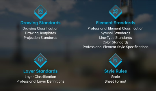
يركّز GeoMap على رسم الخرائط الموحّد بوصفه متطلبه الأساسي. ومن خلال الالتزام الصارم بالمعايير الوطنية والصناعية ومعايير المؤسسة، تدمج المنصة احترافيًا مخططات التوحيد وتضمّن نطاقًا واسعًا من قوالب الخرائط واللوائح والمواصفات. وتُدمج المعايير والضوابط بسلاسة في عملية الإخراج عبر تطبيق مؤتمت أو يدوي، بما يضمن أن تكون جميع الخرائط الناتجة متوافقة ومتسقة بصريًا ومتوافقة مع متطلبات رسم الخرائط بمستوى صناعي.
ضمان جودة المخرجات المهنية
تلبية متطلبات التخطيط الخاصة بكل قطاع
تقليل الأعمال المتكررة وتحسين كفاءة إعداد المخرجات
تمكين سير عمل ذي حلقة مغلقة عبر البيئات المتصلة بالإنترنت وغير المتصلة بها
من نحن